Update: Tropical Depression Imelda Is Still Hitting Southeast Texas Hard

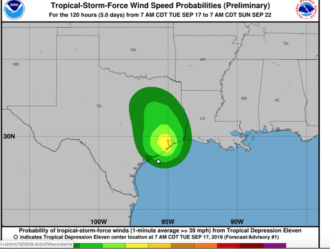
Image: The National Weather Service
Update, 12:15 p.m. September 19
Imelda is still hitting southeast Texas hard, and while the communities east of us, including Beaumont, and the small town of Winnie, among others, are still getting the brunt of the storm, the rain has caused some fallout in Houston as well. Houston and most of the greater Houston area are under a flash flood warning until 1:30 p.m. The best thing you can do right now is stay where you are until this passes, authorities are advising.
George Bush Intercontinental Airport has cancelled flights due to flooding at and around IAH. If you have a flight coming up later today, check on your flight's status before heading out that way. If you can avoid driving right now it's best to do so, especially since you might find your flight has been cancelled once you get there.
Update, 10 a.m. September 19
Tropical Depression Imelda slipped past most of Houston on Wednesday, causing some flooding in specific areas but without bringing about the catastrophic city-wide flooding that had been initially predicted. But while the Bayou City has more or less been spared, for now, communities to the northeast have found themselves in the crosshairs of the rain-heavy storm, which has dropped as much as 35 inches in some isolated locations. The storm is now continuing to make a slow progress over the area, as it moves out of Harris County and passes over Chambers, Montgomery, and Jefferson Counties, according to the National Weather Service.
A flash flood emergency has been issued to the northeastern section of Harris County, with Kingwood, Humble, Huffman, Crosby, and Sheldon all singled out as particularly in danger through 11:15 a.m., according to the NWS. Residents in these areas are being asked to shelter in place and stay off the roads until the storm passes. Montgomery, Liberty, Fort Bend, and Chambers counties are all included in the flash flood watch that will go through 7 p.m. Thursday.
Meanwhile, the storm has pummeled Beaumont and the communities around it, with drivers stuck in their cars, homes flooding that didn't even flood during Harvey, and hundreds calling in to be rescued. Even the local TV station KMBT was forced to evacuate when the flood waters rose up into their studio, according to various reports.
And Houston isn't out of the woods. Mayor Sylvester Turner told the Chron this isn't over yet. "We are anticipating more rain coming into the Houston area from the north heading south," Turner stated. "It could be heavy. Please be careful driving especially on feeder roads."
Update, 10:25 a.m., September 18
The rain came down steadily all night, but despite the dire predictions and the amount of national media with eyes trained on Houston to chronicle this pending disaster, you may have noticed this morning that, well, nothing much has happened, so far.
Yes, various educational entities, including Galveston ISD, Texas City ISD, Houston Community College, Texas A&M University-Galveston, the College of the Mainland, and Harris County Department of Education have cancelled classes and are closed today, but at this point it might be tempting to brush all the hype off and disregard this tropical depression (the National Weather Service downgraded Imelda on Tuesday evening) as a lot of wet and worry, signifying nothing. But this is no time to get too relaxed. For one thing, high-water spots have popped up on the south side of the city, including sections of the Gulf Freeway, Loop 610 West and the South Beltway, so be sure and check TranStar before heading out.
Also, while we're getting a breather this morning, the rain is expected to pick back up this afternoon. At that point, with water-soaked ground and bayous and other waterways already carrying the runoff from the first bands of the storm, things could get pretty nasty. We'll be keeping an eye on it here, and will update as the rest of this storm—we're likely in for another 24 hours—passes by on its way up north.
Houston, we're about to get hit by a deluge. Tropical Storm Imelda is forecast to move slowly from the Gulf of Mexico into Texas over the rest of the week, bringing more bands of heavy rain like the ones that were already passing through Tuesday morning. That rain is expected to only get more frequent as the storm ambles its way inland over the next few days. The National Weather Service has already issued a flash flood watch for Harris, Galveston, Chambers, Liberty, Brazoria, Matagorda and Fort Bend counties starting at 1 p.m. Tuesday and through 1 p.m. Wednesday, and that watch could be extended as this storm plays out.
While Imelda isn't expected to get too crazy, the real worry is the amount of rain we're about to get, which could be anywhere from one to five inches in most areas (assuming none of the tracts of rain linger in any one spot for too long) or as much as 15 inches (if one of the rain bands does stall out over a particular area).
As we all prepare to wade through what is expected to be a very soggy rest of the week, here are a few things you should keep in mind:
1. Turn around, don't drown.
This applies whether you're a lifelong Houstonian or you just got here yesterday. If there is a puddle on the road in front of you and you don't know for a fact that it's only an inch of standing water, do not drive into it. The slogan might sound kind of cute, but we have it around here because of the tragic fact that people have driven their cars into standing water collecting in underpasses, dips in the road, and whatever else, and have drowned. Once your car is sinking down in that water, it is nearly impossible to open the doors, as the City of Houston notes, so take everyone's word on this and don't find out for yourself. Pay special attention in the early morning and late at night, the times when there's both less visibility on the roads, and less people in general, meaning there won't even be someone who can try to help you if you end up in trouble.
2. Follow Space City Weather.
Space City Weather won all of our hearts during Harvey when the website created by former Chron reporter Eric Berger became the go-to for reasonable, up-to-the-minute coverage of that monster of a storm, and the site has stayed a local fave ever since. If you want to know what's going on, trust our local news outlets of course, but for a solidly reported, detailed take of how this storm will be playing out, stick with Space City.
3. This isn't a hurricane yet, so calm down.
Yes, this system morphed from being a simple tropical disturbance into Tropical Storm Imelda on Tuesday afternoon, but that's no reason to go scrambling to Kroger to buy up all of the bottled water, batteries, and wine you can get carry. The main threats here are heavy rainfall and flash floods, according to the National Weather Service, so take some deep healing breaths, and chill. And by all means, buy a bottle of vino if that will help you be your most relaxed self as this storm plays out.
4. Sign up for the Harris County Flood Control District's rainfall and water level alerts.
The new system, available at fwsalerts.org, allows residents to track the amount of water in area creeks, rivers and bayous through gages set up at more than 250 locations across Harris County. Once you've signed up, you can get alerts via text, email or both to let you know how the water levels are doing in your area. Following HCFCD's Twitter is fine, but with this thing you'll have specific information about the areas you are particularly interested in.
5. Check the roads before you head out to that yoga class (or work, or school, or whatever)
Don't just strike out for a destination assuming that everything will be fine. Check the roads before you go with Houston TranStar's real-time maps. Last year Harris County Flood Control collaborated with TranStar to make the maps even more accurate, resulting in a real-time system that indicates the state of the main thoroughfares in the city while showing whether various side streets are underwater as well.


